King Charles III England Coast Path in Essex
About
 King Charles III England Coast Path logo
To celebrate the coronation of His Majesty King Charles III, the England Coast Path has been renamed the ‘King Charles III England Coast Path’, leaving a lasting legacy to be enjoyed by walkers around the entire English coastline.
The King Charles III England Coast Path will be the longest managed coastal path in the world. It will go all the way around the coast of England and will be around 2,700 miles long when it is complete.
Essex boasts 300miles of this National Trail. The path aims to stay as close to the coast as possible. In some places the path heads inland, usually only for short distances. The open sections of the path are well signed, look out for the distinctive acorn waymarkers. Away from towns and villages you will usually find the path has a natural, unmade surface, some areas will get muddy in wet weather. Closer to where people live you might find smooth surfaced paths, and in towns and villages you may be walking on promenades or pavements alongside roads.
The alignment of the Trail was designed by Natural England and their reports are available to view in detail via the links in the table below. The route of the England Coast Path was split down into sections, which were named by their start and end points. Essex has 9 stretches and our progress toward opening them is shown in the table below.
Stretch name
|
Progress
|
|
|
Open to the public
|
|
|
Open to the public
|
|
|
Stage 5: Open
(not yet available for public use - work to establish the route is currently taking place)
|
|
|
Open to the public
|
|
|
Open to the public (see also Coastal Path Access Guides)
|
|
|
Stage 5: Open
(not yet available for public use - work to establish the route is currently taking place)
|
|
|
Stage 5: Open
(not yet available for public use - work to establish the route is currently taking place)
|
|
|
Stage 5: Open
(not yet fully available for public use - work to establish the route is currently taking place) (see also Coastal Path Access Guides)
|
|
|
Stage 4 and 5: Partially approved (not yet available for public use - work to establish the route is currently taking place on approved lengths)
|
Map of progress
A map of progress is available from GOV.UK
Information about the trail sections including accommodation, points of interest and services along the route can be seen via the National Trails website map for the England Coast Path in the East.
Coastal Path Access Guides
Guides to sections with higher levels of accessibility for wheeled users
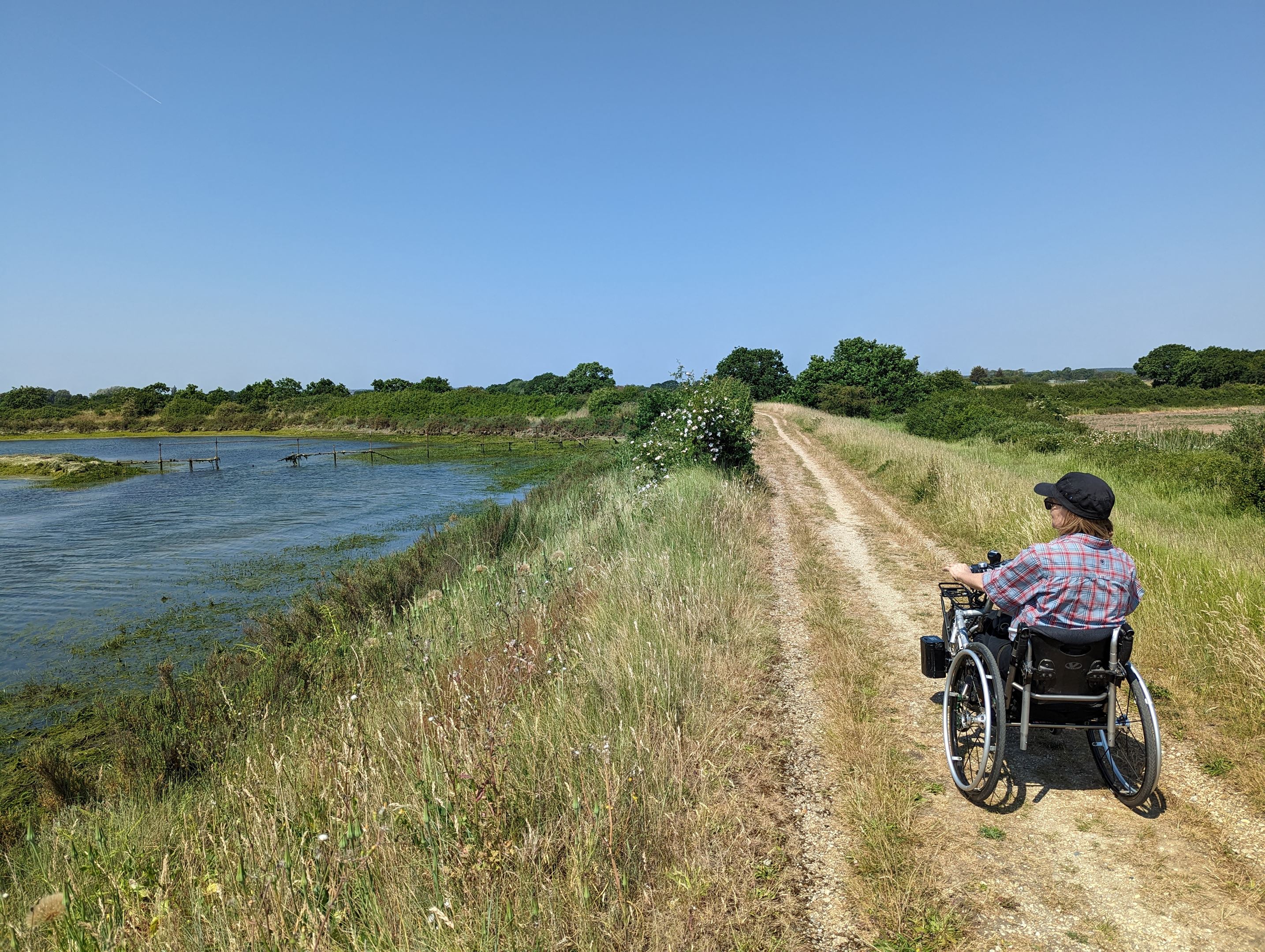
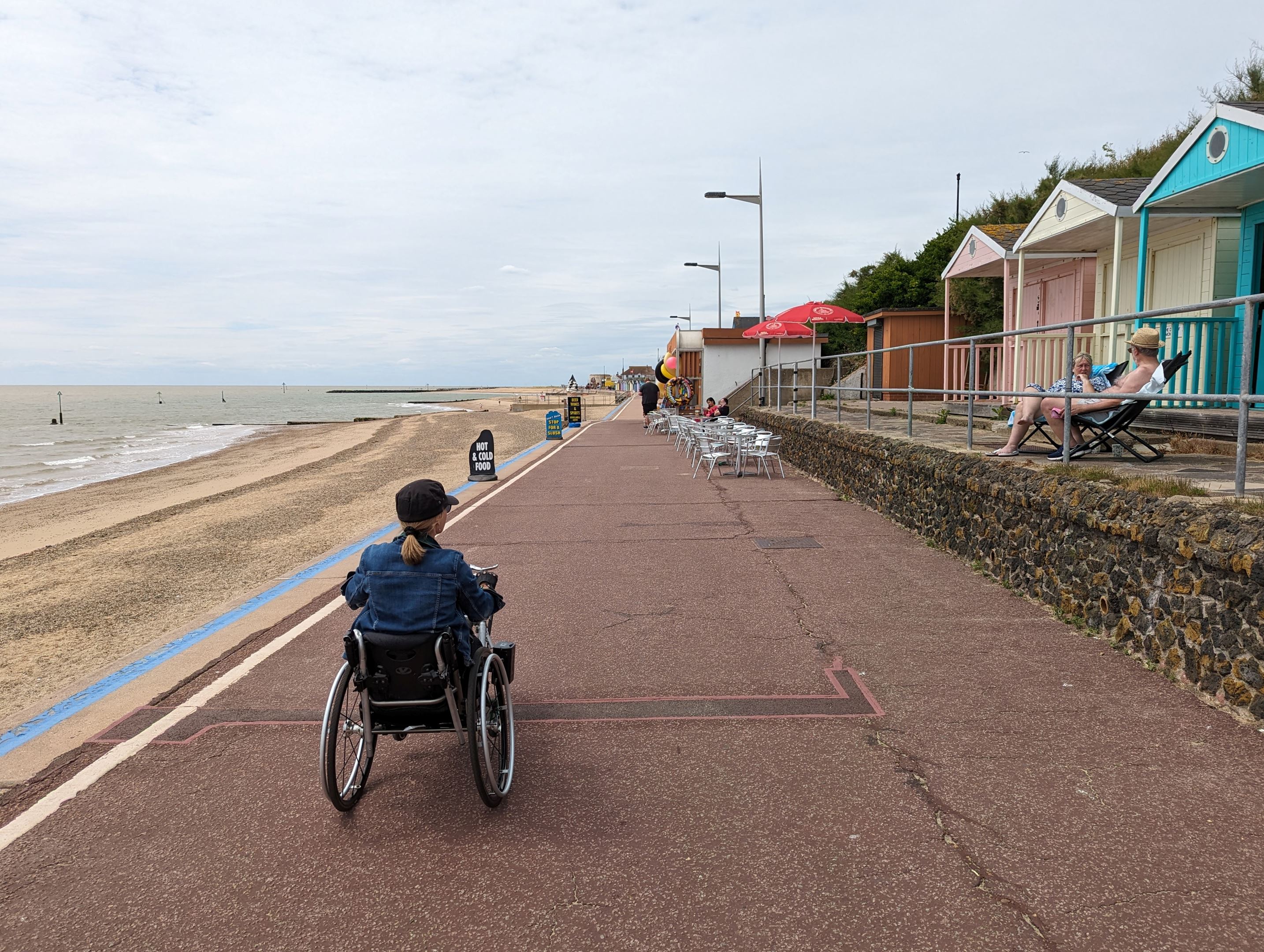
In 2009 the Marine and Coastal Access Act first tasked Natural England with a duty to secure a long-distance walking trail around the coastline of England. In Essex we are fortunate in that continuous public access around our local coastline has already been achieved over very significant distances. Unsurprisingly though, not all of this is wheelchair accessible. This page introduces guides to sections of Essex Coast Path with higher levels of access for wheeled users. This work is new and will build overtime, as accessibility around the coast is optimised, and new guides are added.
Our approach to Access
The guides are produced by Essex Local Access Forum. They are produced by volunteers working to shared ELAF guidance.
The main focus of the guides is on path suitability for wheeled users, including users of manual and motorised chairs (independent and accompanied), and users of mobility scooters and all-terrain vehicles. The guides may though also benefit parents with young children in pushchairs, and older or mobility-restricted walkers.
All of the walk sections identified are step-free, level or mostly level, and free of man-made barriers. They are however mixed in character, terrain and length, and not all will suit all wheeled users. We recognise the wide range of ability within disability, and an increasingly wide range of all-terrain equipment expanding horizons for chair users. Our focus is on good quality information enabling users to make their own informed choices.
Distance: 3m / 5km
Description: A walk along the sea wall of the Blackwater Estuary, with Osea Island opposite, across the mudflats. An internationally important site for wintering birds. A step and barrier-free walk; mostly level; some mixed uneven terrain.
Distance: 2.2m / 3.6km
Description: A short, well-maintained section of the coastal path running along Essex Sunshine Coast. An entirely hard-surfaced, step and barrier-free walk; mostly level.
Be in touch!
We are looking to expand on these routes and regularly seeking to improve and update them. To contact us with new route suggestions or with feedback, please email us: ELAF@essexhighways.org