A104 Epping New Road - Safer Roads Scheme
Introduction
The A104 Epping New Road is an important A-road linking Epping, Theydon Bois, the M25 (via Junction 26) and the M11 (via Junction 7) with Greater London. Within Essex, the road runs through Epping Forest, which is well used for leisure and recreation by pedestrians, cyclists and equestrians.
This scheme will introduce a number of proposals to provide a safer road environment for all road users. It will work in partnership with the Epping Forest Transport Strategy, for further changes in the area outside the safe roads brief.
Why?
The Department for Transport (DfT) identifies the 50 most dangerous stretches of road in England on an annual basis through the Road Safety Foundation. Improvements are then targeted with funding through the DfT Safer Roads Fund (SRF).
The A104 Epping New Road, between the Wake Arms roundabout and the border between Essex and Redbridge, was one of the stretches of roads identified.
The A104 Epping New Road is long and straight, and average vehicle speeds typically exceed the current 40mph speed limit. This has been identified as a key safety issue. The area is shared with pedestrians trying to access Epping Forest who are at risk when crossing from designated car parks and cyclists also use this route however it is sub-standard and dangerous.
Earlier this year, Essex County Council was awarded £1.36M by the Safer Roads Fund to deliver a package of work to reduce the risk of accidents on the A104 Epping New Road.
Scheme
Extension of the current 30mph speed limit from its current termination just to the north of Fernside northwards to cover the Rangers Road junction.
Enforcement of the current and extended speed limits by average speed cameras installed along Epping New Road.
- Between Wake Arms Roundabout and the junction with Rangers Road to enforce the current 40mph speed limit.
- Between Rangers Road and the Essex/Redbridge County Boundary to enforce the extended 30mph speed limit.
To discourage unsafe overtaking, we will install central hatching along the length of Epping New Road to help define the carriageway.
We will install kerbed central islands defining crossing points at multiple locations between Wake Arms Roundabout and Rangers Road. These will align with existing car parks and routes through the forest to improve the safety of forest users crossing the road and to change the nature of the road for drivers.
We will remove the advisory cycle route along Epping New Road and encourage encourage cyclists to plan safe routes for their journeys.
We will carry out safety improvements to Robin Hood Roundabout, including signage and road marking improvements.
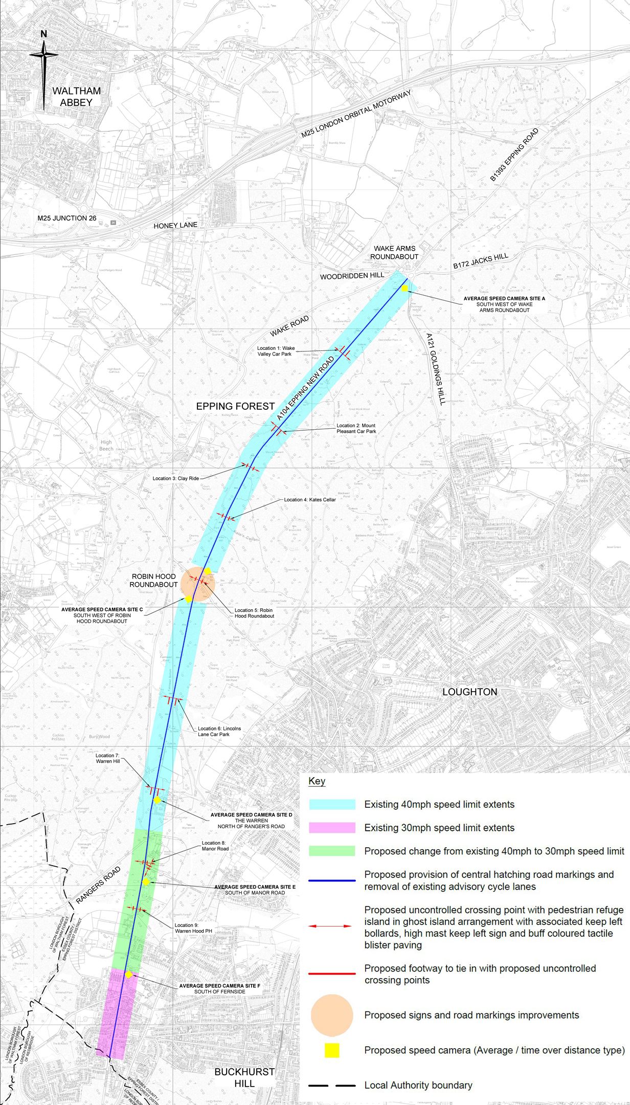
A104 Epping Forest Scheme map
Key
The image is a map showing the A104 Epping New Road and surrounding areas, The map includes various coloured lines and areas indicating the proposed changes explained in the text above. There is a key on the map explaining the colours and symbols:
- Pink indicates existing 40mph speed limit extents
- Green indicates existing 30mph speed limit extents
- Blue indicates proposed change from existing 40mph to 30mph speed limit
- Yellow indicates proposed provision of central hatching road markings and removal of existing advisory cycle lanes
- Red indicates proposed uncontrolled crossing point with pedestrian refuge islands
- Purple indicates proposed redway to tie in with proposed uncontrolled crossing points
- Orange indicates proposed signs and road markings improvements
- A camera symbol indicates proposed speed camera (average speed over distance type)
- A dashed line indicates the local authority boundary.
Next Steps
| Activities |
Date |
| Engagement with key stakeholders |
November/December 2024 |
| Detailed design completion |
March 2025 |
| Traffic Regulation Order (TRO) consultation |
March 2025 |
| Tender and governance |
April to August 2025 |
| Construction |
Summer 2025 |